HAVE ANY QUESTIONS? CLICK HERE
reservations@whispers.co.bw
E-mail Address
Destinations
Chobe National Park
Whether arriving by air or road, the first glimpse of the Chobe River is always breath-taking. It appears as a swathe of bright, blue ribbon, winding its way through the tiny town of Kasane and out into the Chobe National Park's wilderness. One of Africa's most beautiful rivers, the Chobe, supports a diversity and concentration of wildlife unmatched in Botswana.
Established in 1968, Chobe National Park covers approximately 11,700 sq km, encompassing floodplains, swamps and woodland. The Chobe River forms the park's northern boundary, which includes four distinct geographical areas: the Chobe Riverfront: the Ngwezumba pans; Savuté; and Linyanti.
The most accessible and frequently visited of Botswana's big game country, the Chobe Riverfront, is most famous for the large herds of elephants and Cape Buffalo that converge on the riverbank to drink during the dry winter months.
During this season, on an afternoon game drive, you may see hundreds of elephants at one time. The main Serondella Road sometimes becomes impassable as scores of family herds cross the main road to make their way to the river to drink, bathe and play.
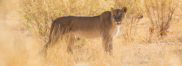
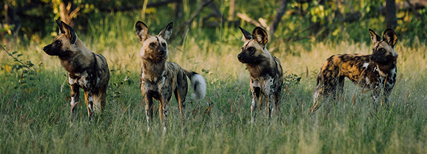
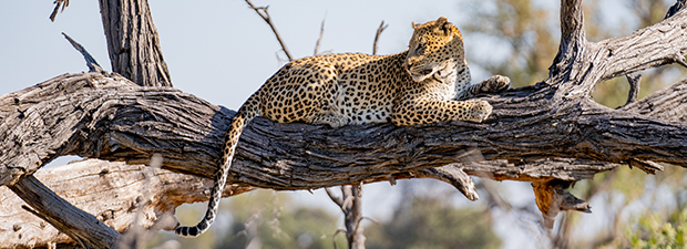
Driving the tracks and trails close to the riverbank, you may see as many 15 different species of animals on any one drive. Common species include waterbuck, lechwe, puku (endemic to this area), giraffe, kudu, roan and sable, impala, warthog, bushbuck, monkeys and baboons, along with the accompanying predators such as lion, leopard, hyena and jackal, who are never far away.
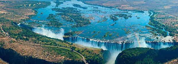
Victoria Falls
Victoria Falls (Lozi: Mosi-oa-Tunya, "Thundering Smoke"; Tonga: Shungu Namutitima, "Boiling Water") is a waterfall on the Zambezi River in southern Africa, which provides habitat for several unique species of plants and animals. It is located on the border between Zambia and Zimbabwe and is one of the world's largest waterfalls, with a width of 1,708 m (5,604 ft).
Archeological sites and oral history describe a long record of African knowledge of the site. Though known to some European geographers before the 19th century, Scottish missionary David Livingstone identified the falls in 1855, naming them Victoria Falls after Queen Victoria. Since the mid 20th century, the site has been an increasingly important source of tourism. Zambia and Zimbabwe both have national parks and tourism infrastructure at the site. Research in the late 2010s found that precipitation variability due to climate change is likely to change the character of the fall.
Savuti
Found at the heart of the park, Savuti boasts most of the Chobe region species, except for water-loving antelope. It is best known for its large resident populations of predators, particularly lion, cheetah and hyena.
The Savuti channel flows from the Linyanti River for about 100 km, carrying water away from the river, releasing it into a vast swampland called the Savuti Marsh, and further south on to the Mababe Depression, also fed by the Ngwezumba River from the northeast. The Mababe – immense and flat and fringed by thickets of trees – was once part of the Makgadikgadi super-lake. When filled with water, it attracts thousands of migratory birds and animals, vast herds of zebra.
Geographically, Savuti is an area of many curiosities. One of its greatest mysteries is the Savuti channel itself, which has over the past 100 years inexplicably dried up and recommenced its flow several times. Attributed by some to plate tectonics, this irregular water flow results in numerous dead trees lining the channel. These trees germinate and grow when the channel is dry, but they drown when the channel flows again.
At the extreme northern reaches of Botswana, between the Chobe National Park to the east and the Okavango to the south, are the extensive Kwando, Selinda and Linyanti concessions. These properties offer superb wildlife viewing – and terrain to rival the physical beauty of the Okavango.
Khwai Concession
Khwai Concession is a region in the north-eastern Okavango Delta boasting an impressive fauna. It is a superb alternative to the Moremi Game Reserve, which can be visited all year around.The 1800 km² large Khwai Concession is situated right next to the Moremi Game Reserve. Formerly a hunting concession it is today administered by the local community as recreational area. It retrieves its name from the Khwai River, the northern “finger” of the mighty Okavango Delta, which forms the most important source of life in the region. The Khwai Concession is a good example for eco-tourism. All income generated are received by the local community (Khwai Community Trust).
Moremi Game Reserve
In 2008, Moremi Game Reserve was voted 'best game reserve in Africa' by the prestigious African Travel and Tourism Association at South Africa's premier tourism fair, Indaba.
It is the first reserve in Africa to be established by local residents. Concerned about the rapid depletion of wildlife in their ancestral lands – due to uncontrolled hunting and cattle encroachment – the Batawana people of Ngamiland, under the leadership of the deceased Chief Moremi III's wife, Mrs Moremi, took the bold initiative to proclaim Moremi a game reserve in 1963. It is the only officially protected area of the Okavango Delta. As such, it holds tremendous scientific, environmental and conservation importance. To this day, Moremi ranks as one of the most beautiful reserves in Africa, possibly in the world.
Moremi Game Reserve is situated in the central and eastern areas of the Okavango. It includes the Moremi Tongue and Chief's Island, boasting one of the continent's wealthiest and most diverse ecosystems.
This makes for spectacular game viewing and bird watching, including all significant, naturally occurring herbivore and carnivore species in the region and over 400 species of birds, many migratory and some endangered. Both Black and White Rhino have recently been re-introduced, making the reserve a 'Big Five' destination.
Covering approximately 3,900 sq. km, where land and Delta meet, Moremi Game Reserve is a profoundly picturesque preserve of seasonal and perennial floodplains. The landscape includes waterways, lagoons, pools, pans, grasslands, and forests. This terrain makes driving Moremi's many tracks and trails delightful and exceptionally inspiring.
Maun
Botswana's tourism capital lies on the southern fringes of the Okavango Delta. Despite recent modernisations, Maun carries the feeling of a dusty, frontier town. Maun is the gateway into the Delta for many tourists and often into Botswana. The busy airport receives direct flights from Johannesburg and Gaborone.
Maun is the administrative centre of Ngamiland District and the seat of power of the Batawana people. The Batawana are an offshoot of the Bangwato of Serowe. Following a chieftainship dispute in the late 18th century, Kgosi (chief) Tawana and his people left Serowe and settled in Ngamiland. First establishing their capital at Lake Ngami, then Toteng, Tsao and finally, in 1915, in Maun. Ngamiland District comprises a fascinating variety of ethnic groups: the Hambukushu, Basubiya and Bayei – all with central African origins. These groups know the Okavango intimately, having expertly exploited and utilised its abundant resources for centuries. Cultural groups also include the Banoka – the River Bushmen, the Okavango's original inhabitants - the Bakgalagadi, and the Baherero. The Herero people originate from Namibia. Women of the tribe can be seen wearing brightly coloured Victorian-style dresses as they stroll along the town roads or sit outside their traditional rondavels.
Frequently, the 'people' side of the Okavango is overlooked, with tourists merely using Maun as a transit point to the Delta. However, exploring the villages along the western fringes of the Delta and into the panhandle is worth the time and effort. Those that make this additional effort find it becomes a real highlight of their travels in Botswana.
The dramatic surge in the numbers of tourists coming to Botswana in the 1980s brought equally dramatic changes to Maun. Safari companies abound, and their signposts dot the sandy parking lots. Modern malls, shops, hotels and guesthouses have sprung up everywhere. Now virtually any food item – from champagne, French cheeses, and chocolates down to commonplace necessities – can be purchased easily.
Meanwhile, the timeless Thamalakane River meanders lazily through the town, setting the scene and mood for what lies ahead
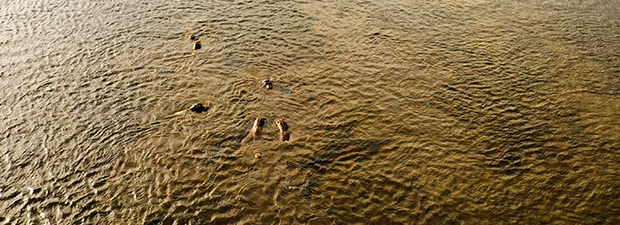
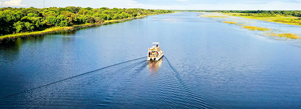
Kasane
The gateway to Chobe National Park, Kasane is an essential point of debarkation for the nearby Victoria Falls in Zimbabwe and Livingstone in Zambia and Namibia's Caprivi Strip.
Spread along the Chobe River banks, Kasane presents an array of hotels, guest houses and campsites that accommodate visitors to the national park. Some are splendidly situated, with beautiful views of the river and its wildlife.
Kasane now boasts small shopping malls where all essential provisions can be purchased, along with arts and crafts. While its main attraction is the park that lies a mere 10 km away, there are also attractions in and around the town. Visitors can plan flexible land and water-based activity itineraries, including morning and afternoon game drives and boat cruises. An essential addition to any itinerary during a visit to Kasane is a day trip to the majestic Victoria Falls, just 80 km away.
About Us
Address
Po Box 326 AAH
Gaborone, Botswana
Call Us
+267 73 422 670
Email Us
reservations@whispers.co.bw